File:Vvardenfell Travel Routes and Intervention Zones.jpg

Size of this preview: 663 × 600 pixels. Other resolutions: 849 × 768 pixels | 10,200 × 9,225 pixels.
Original file (10,200 × 9,225 pixels, file size: 9.98 MB, MIME type: image/jpeg)
SummaryEdit
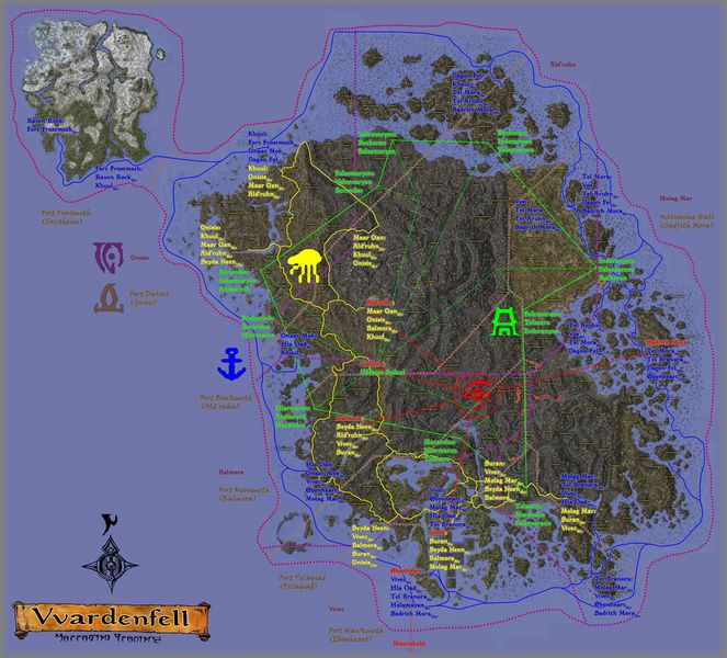
A high resolution composite map using the Morrowind Satellite Map which lists boat & silt strider travel points and destinations, Mage's Guild and propylon chamber teleportation links, and approximated divine & almsivi intervention zones, all overlapping. This map attempts to assume the "real" travel route boat & silt strider travel services.
LicensingEdit
| This file is ineligible for copyright and therefore in the public domain, because it consists entirely of information that is common property and contains no original authorship. |
File history
Click on a date/time to view the file as it appeared at that time.
| Date/Time | Thumbnail | Dimensions | User | Comment | |
|---|---|---|---|---|---|
| current | 03:54, 4 December 2023 | | 10,200 × 9,225 (9.98 MB) | IArePant (talk | contribs) | A high resolution composite map using the <span class=plainlinks>[https://gamemap.uesp.net/mw/ Morrowind Satellite Map]</span> which lists boat & silt strider travel points and destinations, Mage's Guild and propylon chamber teleportation links, and ap... |
- You cannot overwrite this file.
File usage
This file is not embedded on any pages. Please check What Links Here for other links to this file.